实现地图瓦片纠偏的leaflet.mapCorrection.js代码:


//坐标转换
L.CoordConvertor = function () {

    /**百度转84*/
    this.bd09_To_gps84 =  (lng,lat) {
        var gcj02 = this.bd09_To_gcj02(lng,lat);
        var map84 = .gcj02_To_gps84(gcj02.lng,gcj02.lat);
        return map84;
    }

    *84转百度this.gps84_To_bd09 = .gps84_To_gcj02(lng,1)">var bd09 = .gcj02_To_bd09(gcj02.lng,1)"> bd09;
    }

    *84转火星this.gps84_To_gcj02 = var dLat = transformLat(lng - 105.0,lat - 35.0);
        var dLng = transformLng(lng - 105.0,1)">var radLat = lat / 180.0 * pi;
        var magic = Math.sin(radLat);
        magic = 1 - ee * magic * magic;
        var sqrtMagic = Math.sqrt(magic);
        dLat = (dLat * 180.0) / ((a * (1 - ee)) / (magic * sqrtMagic) * pi);
        dLng = (dLng * 180.0) / (a / sqrtMagic * Math.cos(radLat) * pi);
        var mgLat = lat + dLat;
        var mgLng = lng + dLng;
        var newCoord = {
            lng: mgLng,lat: mgLat
        };
         newCoord;
    }

    *火星转84this.gcj02_To_gps84 = var coord = transform(lng,1)">var lontitude = lng * 2 - coord.lng;
        var latitude = lat * 2 - coord.lat;
         {
            lng: lontitude,lat: latitude
        };
        *火星转百度this.gcj02_To_bd09 =  (x,y) {
        var z = Math.sqrt(x * x + y * y) + 0.00002 * Math.sin(y * x_pi);
        var theta = Math.atan2(y,x) + 0.000003 * Math.cos(x *var bd_lng = z * Math.cos(theta) + 0.0065;
        var bd_lat = z * Math.sin(theta) + 0.006 {
            lng: bd_lng,lat: bd_lat
        };
        *百度转火星this.bd09_To_gcj02 =  (bd_lng,bd_lat) {
        var x = bd_lng - 0.0065var y = bd_lat - 0.006var z = Math.sqrt(x * x + y * y) - 0.00002 * Math.sin(y *var gg_lng = z * Math.cos(theta);
        var gg_lat = z * Math.sin(theta);
         {
            lng: gg_lng,lat: gg_lat
        };
        var pi = 3.1415926535897932384626;
    var a = 6378245.0var ee = 0.00669342162296594323var x_pi = pi * 3000.0 / 180.0var R = 6378137;

     transformLat(x,1)">var ret = -100.0 + 2.0 * x + 3.0 * y + 0.2 * y * y + 0.1 * x * y + 0.2 * Math.sqrt(Math.abs(x));
        ret += (20.0 * Math.sin(6.0 * x * pi) + 20.0 * Math.sin(2.0 * x * pi)) * 2.0 / 3.0;
        ret += (20.0 * Math.sin(y * pi) + 40.0 * Math.sin(y / 3.0 * pi)) * 2.0 / 3.0;
        ret += (160.0 * Math.sin(y / 12.0 * pi) + 320 * Math.sin(y * pi / 30.0)) * 2.0 / 3.0 ret;
    }

     transformLng(x,1)">var ret = 300.0 + x + 2.0 * y + 0.1 * x * x + 0.1 * x * y + 0.1 *;
        ret += (20.0 * Math.sin(x * pi) + 40.0 * Math.sin(x / 3.0 * pi)) * 2.0 / 3.0;
        ret += (150.0 * Math.sin(x / 12.0 * pi) + 300.0 * Math.sin(x / 30.0 * pi)) * 2.0 / 3.0 ret;
    }
}

L.coordConvertor =  () {
    return new L.CoordConvertor()
}

L.tileLayer.chinaProvider =  (type,options) {
    options = options || {}
    options.coordType = getCoordType(type);
     L.TileLayer.ChinaProvider(type,options);

    获取坐标类型
     getCoordType(type) {
        var parts = type.split('.'var providerName = parts[0];
        var zbName = "wgs84"
        switch (providerName) {
            case "Geoq":
            case "GaoDe"case "Google":
                zbName = "gcj02";
                break;
            case "Baidu":
                zbName = "bd09"case "OSM"case "TianDiTu":
                zbName = "wgs84";
        }
         zbName;
    }
};

L.GridLayer.include({
    _setZoomTransform:  (level,_center,zoom) {
        var center = _center;
        if (center != undefined && .options) {
            if (this.options.coordType == 'gcj02') {
                center = L.coordConvertor().gps84_To_gcj02(_center.lng,_center.lat);
            } else this.options.coordType == 'bd09' L.coordConvertor().gps84_To_bd09(_center.lng,_center.lat);
            }
        }
        var scale = ._map.getZoomScale(zoom,level.zoom),translate = level.origin.multiplyBy(scale)
                .subtract(._map._getNewPixelOrigin(center,zoom)).round();

        if (L.Browser.any3d) {
            L.DomUtil.setTransform(level.el,translate,scale);
        } else {
            L.DomUtil.setPosition(level.el,translate);
        }
    },_getTiledPixelBounds:  (_center) {
        var map = ._map,mapZoom = map._animatingZoom ? Math.max(map._animateToZoom,map.getZoom()) : map.getZoom(),scale = map.getZoomScale(mapZoom,._tileZoom),pixelCenter = map.project(center,1)">._tileZoom).floor(),halfSize = map.getSize().divideBy(scale * 2);

         L.Bounds(pixelCenter.subtract(halfSize),pixelCenter.add(halfSize));
    }
});
Demo主要代码:
index.html代码:
<!DOCTYPE html>
<html>

head>
    title>Leaflet</>

    meta charset="utf-8" />
    http-equiv="X-UA-Compatible" content="IE=edge"name="viewport"="width=device-width,initial-scale=1"link rel="stylesheet" href="libs/leaflet/leaflet.css"="css/index.css"script type="text/javascript" src="libs/jquery-1.9.1.js"></script="libs/leaflet/leaflet-src.js"="libs/leaflet-plugins/proj4-compressed.js"="libs/leaflet-plugins/proj4leaflet.js"="libs/leaflet-plugins/leaflet.baidu.js"="libs/leaflet-plugins/leaflet.ChineseTmsProviders.js"="libs/leaflet-plugins/leaflet.mapCorrection.js"bodydiv id="map" style="cursor:default;"div="mouseposition"="mapzoom"<!-- 用于显示调试信息 -->
    div
        style="display:none; position:absolute; right:0; bottom:30px; background-color:transparent; width:1000px; height:30px; margin-right:3px; z-index:99999; border:solid 1px transparent;">
        input ="text" id="msg" value=""
            style="width:990px; font-size:12px; padding-left:3px; padding-right:3px; " ="display:none; position:absolute; left:20px; top:20px; background-color:transparent; width:1200px; height:30px; z-index:99998; border:solid 1px transparent;"="button" onclick="alert('1')"="测试按钮" ="config/config.js"="module"="js/index.js">
index.js代码:
import { Map } from './map.js'
import { Marker } from './marker.js'

let map =  Map(tileUrl,{
    centerLatLng: L.latLng(31.81880456,117.18087366),mapBounds: L.latLngBounds(L.latLng(31.0,116.6),L.latLng(32.6,117.8))
});

let marker = new Marker(117.18087366,31.81880456,{
    id: 1
});

map.deviceLayer.addLayer(marker.marker);
map.js代码:
代码中 new L.TileLayer 时,添加属性 coordType: 'gcj02' ,即可实现高德地图瓦片偏移的纠偏
如果是百度地图瓦片,则添加属性 coordType: 'bd09' 即可
*
 * 地图
 */
class Map {

    map
    deviceLayer = L.layerGroup()

    options = {
         L.latLng
        centerLatLng: undefined, L.latLngBounds
        mapBounds: undefined
    }

    constructor(tileUrl,options) {

        Object.assign(.options,options);

        let tileLayer =  L.TileLayer(tileUrl,{
            minZoom: 8'gcj02'
        });

        this.map = new L.Map('map'.options.centerLatLng,zoom: 12.options.mapBounds,layers: [tileLayer],attributionControl: falsethis.map.addLayer(this.deviceLayer); 设备图层

        L.control.scale().addTo(this.map); 比例尺

        显示经纬度和地图层级
        let this_ = this.map.addEventListener("mousemove",1)"> (e) {
            this_.showMousePosition(e);
            this_.showMapZoom();
        });
        this.map.addEventListener("zoomend",1)"> (e) {
            this_.showMapZoom();
        });
    }

    showMousePosition(e) {
        if (!.mousePositionDiv) {
            this.mousePositionDiv = $('#mouseposition');
        }
        this.mousePositionDiv.text(e.latlng.lng.toFixed(8) + "," + e.latlng.lat.toFixed(8));
    }

    showMapZoom() {
        .mapZoomDiv) {
            this.mapZoomDiv = $('#mapzoom'this.mapZoomDiv.text(.map.getZoom().toString());
    }
}

export { Map }
完整Demo代码下载:
代码实现的功能:百度、高德离线地图瓦片加载和纠偏
代码使用了ES6模块化开发,必须部署在服务器上才能在浏览器中访问,可以使用IIS或Tomcat部署
效果图:
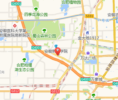
高德地图:
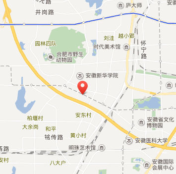
百度地图:
参考github:
https://github.com/gisarmory/Leaflet.InternetMapCorrection
 设计方案是工程建设最关键的环节,也是影响城市规划的基本因...